


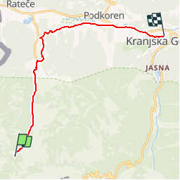
Via Alpina R15 var: Dom Tamarju - Kranskja Gora

michelek
User

Length
10.3 km

Max alt
1108 m

Uphill gradient
55 m
Km-Effort
12 km

Min alt
799 m

Downhill gradient
356 m
Boucle
No
Creation date :
2019-08-03 17:09:11.098
Updated on :
2019-08-03 21:09:30.523
2h27
Difficulty : Medium

FREE GPS app for hiking
 SityTrail
IGN / Geographical institutes
SityTrail Plus
The world is yours!
About
Trail Walking of 10.3 km to be discovered at Unknown, Unknown, Kranjska Gora. This trail is proposed by michelek.
Description
Du joli refuge Tamar, on descend par la piste jusqu'aux tremplins de saut à ski, puis vers Podkoren et enfin Kranskja Gora via la piste cyclable.
Positioning
Country:
Slovenia
Region :
Unknown
Department/Province :
Unknown
Municipality :
Kranjska Gora
Location:
Unknown
Start:(Dec)
Start:(UTM)
401179 ; 5144434 (33T) N.
Comments